CAPITOLA — Stacy Souza mostly works from her home in Capitola’s Jewel Box neighborhood, only a minute or two from the view at Cliff Drive that looks out over the city’s iconic — albeit, recovering — wharf and the majestic Pacific Ocean, perpetually swaying back and forth to varying degrees of intensity.
To keep any semblance of cabin fever at bay, Souza takes at least one walk through the bluff area every day with her 8-year-old German shepherd, Otto.
“There’s a ton of bikers, joggers and dog-walkers, like me,” Souza told the Sentinel during a recent late-morning jaunt. “We all have our community. It’s like, ‘Hi, how are you?’ We know different people and wave.”
But Souza and her fellow scenic enthusiasts, along with the daily gaggle of cars that pack the roadway during peak traffic hours, could one day have to find a new route.
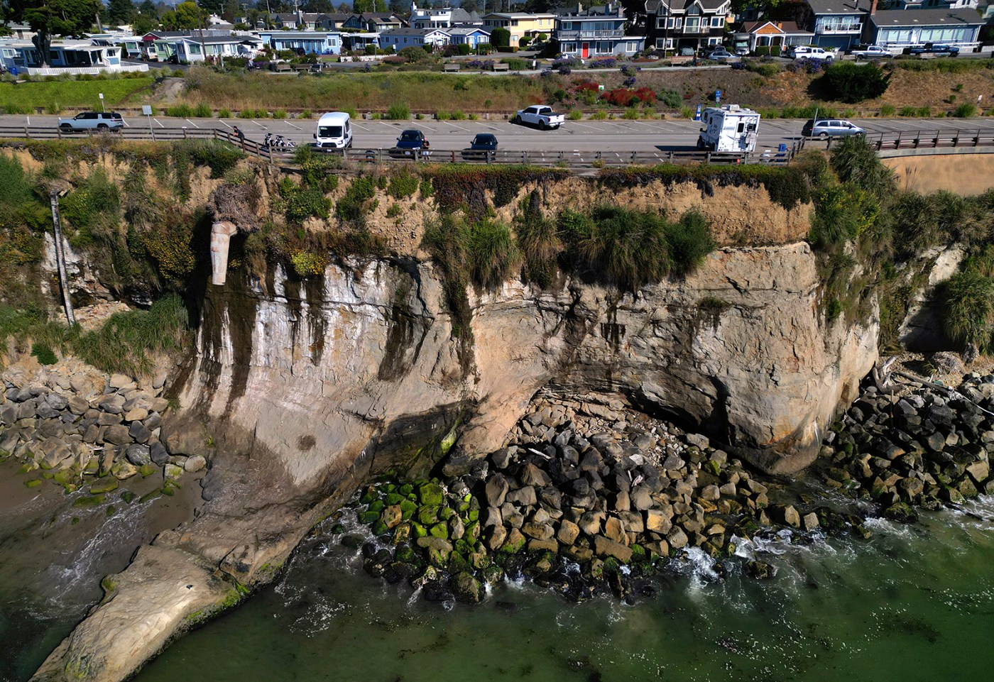
Portions of the towering coastal cliff — estimated by city officials to range from 40-60 feet tall — are steadily eroding into the sea with planners saying that city leaders need to take action to avoid a “when” not “if” scenario of a damaging landslide event.
“No one will put money to when,” said Capitola Public Works Director Jessica Kahn during a report given to the Capitola City Council last month. “but it is definitely something that will happen in the future.”
According to Kahn, the bluff is currently eroding at a rate of about 6 inches annually, though large storm events can accelerate this pace. Most recently, a series of atmospheric river storms and tidal surges in the winter of 2023 resulted in significant erosion, especially at the base of the cliff beneath two parking lots on either end of the road. The storms also further damaged an aging 10-foot soil nail armoring wall near the top of the bluff that was built in 1997.
On top of that, should a seismic event shake loose a larger section of the cliff, it not only threatens those walking or driving by, but could impact a broader swath of residents by taking out critical infrastructure such as sewer and water lines buried in the hillside.
In light of recent events, the city has put together an extensive existing conditions report analyzing a 930-foot section of the road and bluff as part of its Cliff Drive Resiliency Project. It has already secured grants to get the project off the ground, but the City Council must decide which direction it wants to go in.
“Not only are we doing repairs to what has been eroded, but we are also looking into doing a full shoreline protection project on this stretch of road,” said Kahn.
Options on the table
In the aftermath of the 2023 storms, the city secured $9.25 million in permanent restoration funding from the Federal Highway Administration and the city contributed another $1.25 million as a local match, according to Kahn. But these federal funds aren’t available forever and the project must be ready for a construction funding request by September of next year. The California Coastal Commission has also thrown in $500,000 for a project.
“It is likely that the project will cost more than this, but the total cost won’t be known until a final plan is identified,” Kahn recently wrote to the Sentinel, adding that the city is continuing to seek additional funding options.
The road ahead has three routes: protect, adapt, retreat.
The managed retreat method, referred to as “do nothing” in a recent staff report, is straightforward. It involves taking no action as the bluff experiences episodic failures that lead to potential closure of Cliff Drive and redirection away from the locally designated emergency route.
Option 2 buys the city time with short-term adaptions, such as repairs to the eroded sea caves at the foot of the cliff while long-term provisions, such as potentially reconfiguring Cliff Drive into a one-way westbound street, are studied.
But it was the third — and costliest — option that received the most vocal support among the council. Though details of the final project would need to get ironed out, the goal would be to maintain the street where it currently sits with enhanced facilities for bicycles and pedestrians. This may include installation of a new wall with anchors pinned deep inside the heart of the bluff, rock slope protections and creation of new overlooks and improved coastal access.
Capitola Vice Mayor Yvette Brooks said during the meeting that the “protect” option makes the most sense to her, assuming the funding effort proves successful.
“We know we’ve had several natural disasters occur,” said Brooks. “We see the impact, we know that we need to do something.”
Councilmember Joe Clarke felt this same option stood high above the rest.
“We need to, you know, protect it the best we can,” said Clarke. “Option 3 seems by far the best, in my opinion.”
Kahn added that the city hosted a community meeting in the Jewel Box neighborhood about the situation in February, which drew about 20 attendees. The overwhelming feedback from that group, she said, was that “if affordable and feasible, the city should do something to address the erosion on this cliffside.”
Robert Stevens — a representative from CSW/ST2, which was contracted by the city for design services last October — added that his team had a “very productive meeting” with the Coastal Commission, which must approve project permitting, about the various options.
“I think that there’s a path forward,” he said.
Expert weighs in
Related Articles
Road repairs estimated at $3 million after Santa Cruz Mountains landslide
Home insurance at $10,000 a year shows California buyers’ pain
Paul’s Slide on Highway 1 near Big Sur opens Sunday
Slab of cliff at Capitola beach crumbles into sea
Paul’s Slide on Highway 1 on Big Sur coast to open earlier than anticipated
Gary Griggs, a distinguished professor of Earth and Planetary Sciences at UC Santa Cruz who has been studying coastal erosion for 50 years, agreed with other coastal experts that it’s “almost impossible” to predict when a failure could occur. This is due, in part, to the geologic makeup of this section of the county’s coastal cliffs.
“It’s just a tough area to protect because of the nature of the rock and the type of failure,” Griggs told the Sentinel.
The bluffs extending roughly three miles from Pleasure Point down to New Brighton State Beach are primarily composed of Purisma bedrock, relatively young geologically speaking at 2 million to 4 million years old, which sits atop a soft layer of mudstone.
The Purisma is known for having a jointed structure — like a fractured windshield — that can be undermined by crashing waves or, perhaps even more critically, from neighborhood runoff that seeps into the cracks. And with climate change models pointing to more extreme periods of dry summers and heavy rainfall winters, the erosion process could accelerate.
While Griggs, based on his own knowledge of the area and historical photographs, isn’t entirely convinced any action to protect the cliff is needed quite yet, he agreed that the concrete armored wall is the most “straightforward,” as seen at Pleasure Point.
But in the long run, which he admitted has varied definitions, there is no easy answer.
“Sea level is going to keep rising, storms are going to keep coming and we’re not going to be able to hold the line everywhere,” said Griggs. “There may be places we decide are worth protecting.”
Kahn said public engagement opportunities on the resiliency project include an online survey that is yet to launch and a pop-up booth at the July 21 Sunday Art at the Beach event in Capitola Village. A more robust outreach effort will commence once the council formally selects a preferred plan, she added.
Meanwhile, Souza, who was unaware of the city’s efforts, will continue to enjoy daily walks at the picturesque point and hopes to continue to do so for years to come.
“It’s a world-class view,” she said. “I don’t know why we wouldn’t protect it.”


