Three wildfires that ignited amid unusually hot weather in Southern California have caused evacuations.
Related Articles
Jeremy Renner thanks firefighters protecting Lake Tahoe home from Davis Fire
Map: Davis Fire between Reno and Mt. Rose
Evacuations still in effect at Boyles Fire near Clearlake
Out-of-control Line Fire in Southern California threatens more than 36,000 homes and structures
4,000 residents evacuated as fire burn through 30 buildings in Clearlake
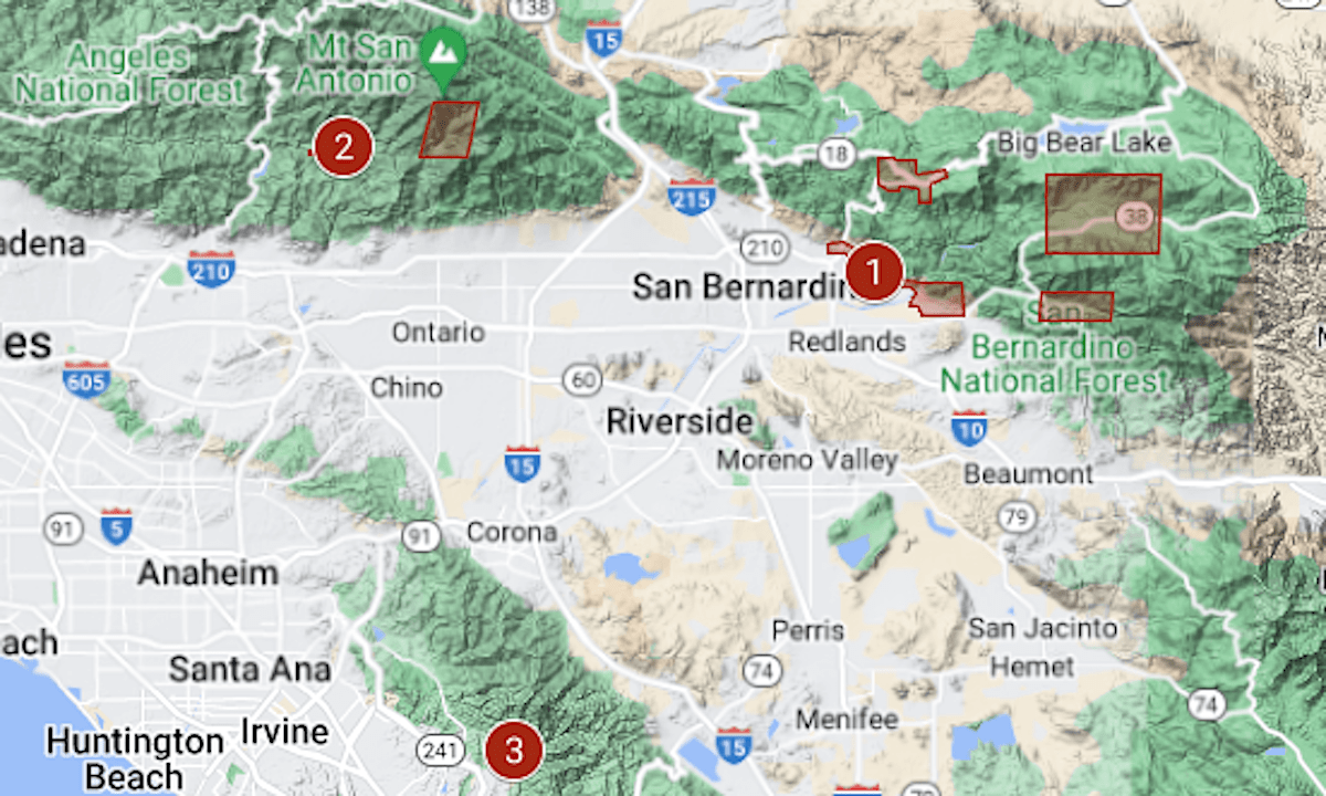
The map above shows their locations, with the evacuation areas marked in red.
A red-flag alert, indicating heightened fire danger because of dry and windy weather, remains in effect until noon Wednesday, Sept. 11, for the mountainous areas of Los Angeles County, the National Weather Service said.
An excessive heat warning through Tuesday evening covers much of Southern California from the San Fernando Valley to the Mexican border.
1/ Line Fire | 26,516 acres (41.4 square miles), 5% containment, 65,600 structures threatened
• Started around 6 p.m. Thursday, Sept. 5, along Base Line Street in Highland, at the edge of the San Bernardino Mountains.
• Burning in a mountainous area of the San Bernardino National Forest. An official of the California Department of Forestry and Fire Protection said Tuesday that crews are confident that the communities at Big Bear Lake can be protected.
• Besides the larger zones noted on the map, evacuations have been ordered for the communities of Angelus Oaks and Mountain Home Village.
• Line is the fifth-largest fire of California’s wildfire season and the only one of the biggest five that is not at least 95% contained.
• It is just to the west of the footprint of the El Dorado Fire, which was started in September 2020 by a pyrotechnic device at a gender-reveal event. El Dorado burned 22,744 acres, and a firefighter was killed.
• For updates and details of the evacuation, see the San Bernardino County emergency map or the Facebook page of CalFire‘s San Bernardino/Mono/Inyo unit.
2/ Bridge Fire | 3,786 acres (5.9 square miles)
• Started around 2 p.m. on Sunday, Sept. 8, near the Bridge to Nowhere Trailhead in the Angeles National Forest.
• Evacuations cover Camp Williams and Baldy Village.
• For updates and details of the evacuation, see the Los Angeles County emergency map.
3/ Airport Fire | 9,333 acres (14½ square miles), 0% containment
• Started around 1 p.m. on Monday, Sept. 9, near a field used by remote-control aircraft hobbyists at the entrance to Trabuco Canyon. Initial indications are that it was sparked unintentionally by an Orange County public works crew using heavy equipment.
• The evacuation order, issued around 3 p.m. Monday, includes homes in the Robinson Ranch neighborhood. Evacuation warnings cover areas of Riverside County as well as Orange County.
• The Airport Fire is in the same area as the December 2020 Bond Fire, which burned 6,700 acres and destroyed 31 structures, and the August 2018 Holy Fire, which burned 23,136 acres and destroyed 18 structures.
• For updates and details of the evacuation, see the Orange County sheriff’s department website.