For my last column, it’s time to hike the legendary Tomales Point Trail — where the long limb of land between the Pacific Ocean and Tomales Bay runs out of continent at Tomales Point.
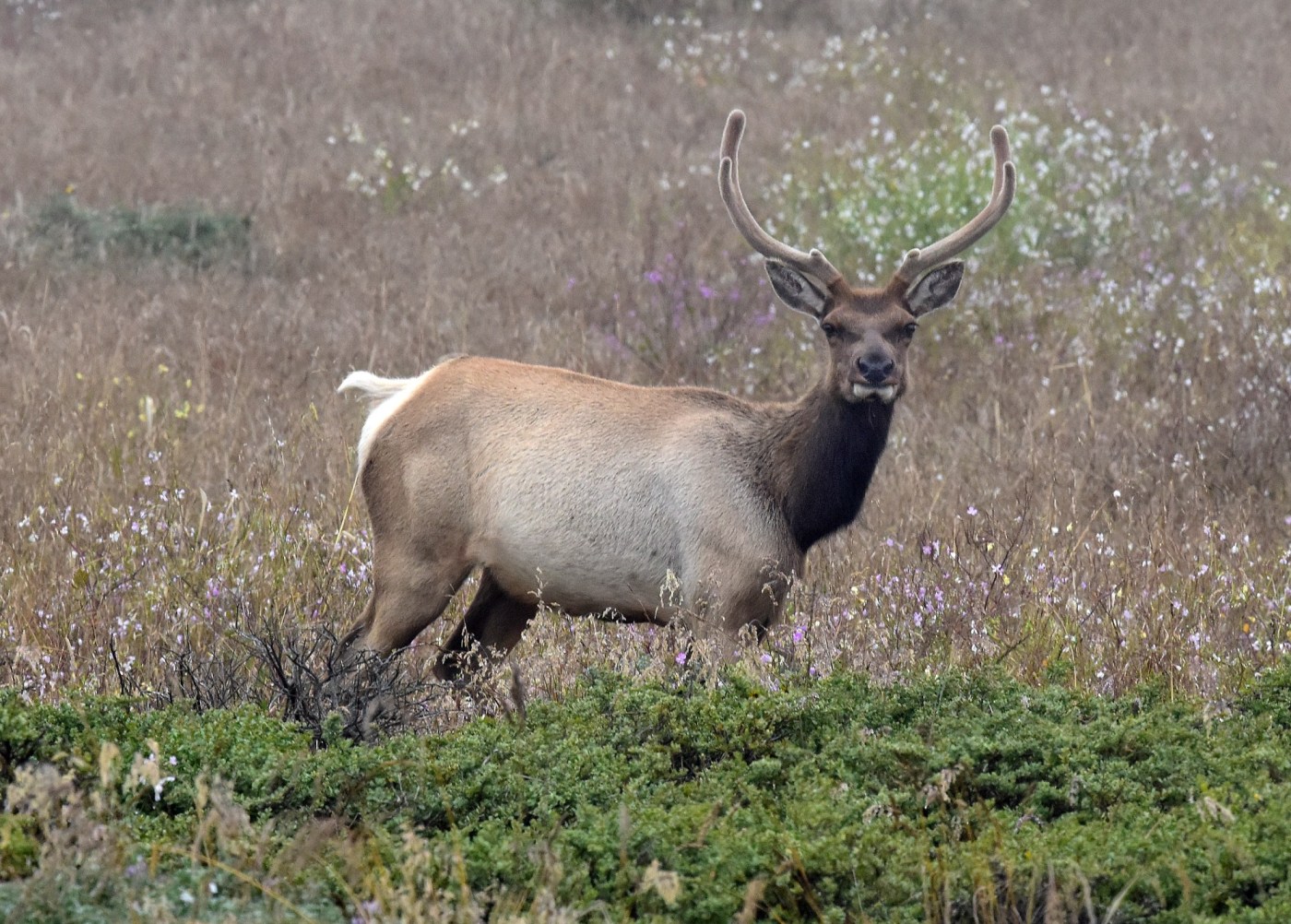
The hike is justly famous for the opportunity to see tule elk — now sometimes separated into groupings comprised of a dominant bull elk and his harem — and the ocean and Tomales Bay that meet at the tip of Tomales Point.
Before we proceed, I wish to thank you readers of the column for giving me your time and attention, two of your most important belongings. I am grateful to Colleen Bidwill, the Marin Independent Journal Lifestyles editor, who gave me the amazing opportunity to write the newspaper’s hiking column and encouraged and supported me throughout. I thank Buz Johanson for being a longtime friend and accompanying me on many of the hikes, and Richard Drake, who has let me use some of his terrific wildlife photos. And love to my wife, Mary — together we have walked many of the column’s trails and all of life’s important paths.
• Summary of the hike: The entire out-and-back hike is about 9.4 miles, but it’s about 6 miles round trip to the shallow pond and Monterey cypress that mark the historic location of Lower Pierce Point Ranch. Or you can turn back earlier, even before the hike up the long hill, if you’re satisfied with your adventure and the amazing views of the Pacific Ocean, Tomales Bay and hopefully some tule elk.
In general, the footing is satisfactory. But on the final push from the former Lower Pierce Point Ranch to the Tomales Point overlook, you must climb uphill on an unmaintained, sandy trail before reaching the ocean bluff and the magnificent view of Tomales Point.
Try to pick a day when it’s clear at the coast with little wind so that hopefully you have good weather. Your odds of it are better now through early November than at almost any other time of the year. As a bonus, the elk are presently more vocal and active because it’s mating season.
Dogs are not allowed. There’re no facilities at the trailhead or along the trail, but there are non-flush toilets just a couple hundred yards down the road toward McClures Beach from the entrance to our trailhead parking lot.
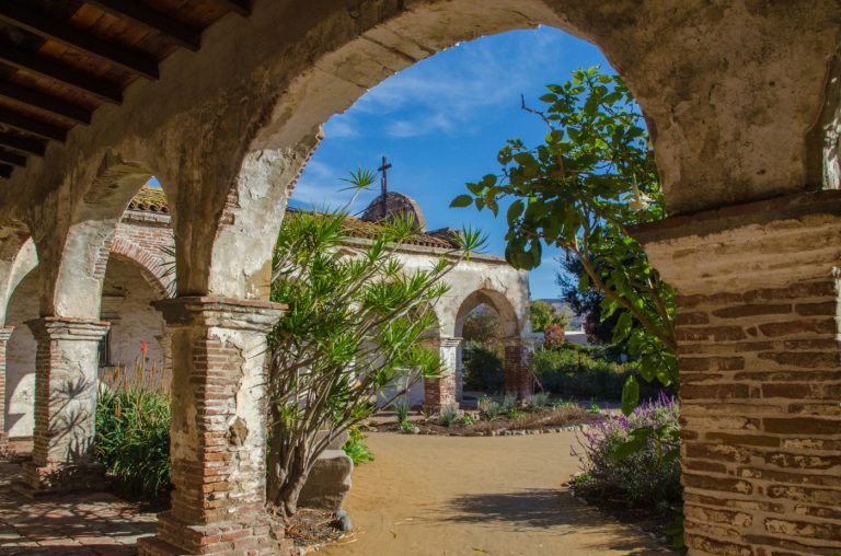
• Getting there: From the junction of Sir Francis Drake and the Shoreline Highway at Olema, turn right on Shoreline Highway toward Point Reyes Station, and then left toward Inverness on Sir Francis Drake just before the bridge leading to Point Reyes Station. Continue through Inverness and beyond until you reach a fork in the road. There, go right on Pierce Point Road all the way to the end at our trailhead parking lot, next to some old ranch buildings. The drive is beautiful and interesting, but from most places in Marin it will take you more than an hour.
• The hike: From our trailhead, we skirt the historic Pierce Point Ranch buildings maintained by the National Park Service, some Monterey cypress and soon hike along bluffs overlooking the ocean. After taking in these exhilarating views, we head inland.
Before we start the climb up the long hill, look toward Tomales Bay as elk often graze in the narrow valley descending to Tomales Bay or on the slopes above it. You may hear the elk before you see them, as the bulls at this time of year are trumpeting their virility.
Before tule elk were reintroduced in 1978 to Marin in the area covered by our hike, they had been extinct in the county for more than 100 years. They were almost extinct everywhere. The last survivors, a small herd of fewer than 10, were discovered in 1874 near Bakersfield on the lands of California’s largest ranch. By the early 1900s, these few elk had multiplied significantly.
Beautiful views await you at Tomales Point. (Photo by Jim Holden)
Related Articles
Marin hike: Heading into the heart of ‘Big Empty’
Marin hike: Head to this historic lighthouse
Looking for the best trails to hike in California? Hit these scenic spots, experts say
He saw his daughter fall from Half Dome. He says safety changes could prevent more tragedies
How to enjoy hiking Marin’s trails more
The two male and eight female tule elk transported to Point Reyes in 1978 have increased in population to hundreds and inhabit three separate areas in Point Reyes. The greatest concentration is located in the area we traverse on our hike. In large part due to the abundant rains of the last two years, the elk appear to be thriving.
Now we walk up the long hill, which is only light to moderate in slope but at times seems to go on forever. At the top, we walk on virtually level ground affording excellent views of the Pacific on one side and Tomales Bay on the other.
Look and listen for tule elk on either side and watch them for a while. The interplay between them is sometimes fascinating, and you may even see some bulls sparring.
We next head down to a shallow pond and some Monterey cypress just beyond, marking the location of Lower Pierce Point Ranch years ago. Sometimes a few elk graze at the pond. From the pond, we hike to the bluffs overlooking Tomales Point on an unmaintained trail of 1.7 miles. It’s not difficult in and of itself, but it’s a bit of a slog because of extensive loose sand.
We finally arrive at the magnificent overview of Tomales Point, a blade of rocks separating the south shore of Tomales Bay from the immense ocean. Marin historian Dewey Livingston told me that, in their own language, the Coast Miwok called the point “Hummingbird’s Beak.” Take in the view with the rolling ocean crashing against the rocks. It’s surely one of the most dramatic scenes you will see on any hike.
The entire adventure is one unique to our area. It’s our treasure, and I hope you have an opportunity to experience it.
Good luck and keep moving.
A longtime avid hiker and Marin resident, Jim Holden is the author of two nonfiction books: “It Happened in Marin” and “Adventurous Lives, Daring Acts.” He can be reached at MarinhikingJim@gmail.com