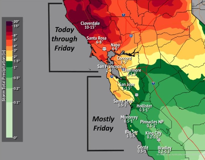
The first atmospheric river storm of the winter rainy season slammed into California on Wednesday. Driven by a powerful “bomb cyclone” off British Columbia, it brought heavy rains to Sonoma and Marin counties, dumping more than 6 inches in the hills above Guerneville by mid-afternoon.
The National Weather Service issued a flood watch through 4 a.m. Saturday for Marin, Sonoma and Napa counties, and a high surf advisory from Big Sur to the Sonoma Coast from with large breaking waves 14 to 22 feet high expected.
But areas south of the Golden Gate Bridge saw little rain in the first wave, with San Francisco, Oakland and the Peninsula receiving only light sprinkles, and San Jose staying largely dry.
“The brunt of this storm is really over the North Bay right now,” said Cindy Palmer, a meteorologist with the National Weather Service in Monterey. “It is trying to sneak south. It’s just not quite there yet.”
More rain should fall across the Bay Area Thursday and especially Friday, Palmer said, as the storm system shifts.
San Francisco is expected to receive 2 to 3 inches by Friday night, with Oakland 1 to 2 inches, and San Jose and Santa Cruz about 1 to 1.5 inches, the National Weather Service said.
Meanwhile, the UC Central Sierra Snow Lab forecast 10 to 20 inches of snow falling along Donner Summit near Lake Tahoe by Friday, just in time for Thanksgiving, the traditional start of ski season. The CHP issued chain controls around noon Wednesday for Interstate 80 between Truckee and Cisco Grove.
A color-enhanced satellite image from the National Oceanic and Atmospheric Administration shows the “bomb cyclone” and atmospheric river that are bringing wet conditions to California on Wednesday Nov. 20, 2024. (Image: NOAA)
Overall, the multi-day storm was expected to bring the most rain to the Bay Area of any storm system in roughly 9 months. While its slow start may have been disappointing to some in the drier parts of the Bay Area, that contrasted with rising creeks, flooded storm drains, and downed trees in the North Bay, where wind gusts reached 50 mph at times.
Computer models and satellite imagery showed a generally wet pattern for the Bay Area continuing through Monday and possibly beyond.
“I’d rather have smaller systems spread out over 5 days than all of it in one day,” said Jan Null, a meteorologist with Golden Gate Weather Services in Half Moon Bay. “It causes less mayhem.”
By 2 p.m. Wednesday, rain totals were highest in the north, dropping farther south. Santa Rosa received 3.3 inches of rain; Mount Tamalpais in Marin County 1.59 inches; Richmond .25 inches; San Francisco .11 inches; Oakland .03 inches, and San Jose no measurable rain.
Much of Northern California needs the precipitation. Due to months of dry conditions, a red flag warning for extreme wildfire danger was in effect for parts of the Bay Area as recently as Election Day two weeks ago.
Through Wednesday morning, San Francisco, Oakland and San Jose all had received only half an inch of rain or less since Oct. 1 — only about a quarter of the historical average. The new rain should bring most areas up to historical averages, forecasters said.
Wednesday storm was being driven by a “bomb cyclone” that currently sits off the coast of British Columbia. A large mass of warm moist air from the south collided with a mass of cold air from Alaska. That caused the warm air to rise, and the barometric pressure to fall dramatically, creating an enormous swirling air mass.
That system pulled in an atmospheric river — or long, moisture-rich plume of air from north of Hawaii — to California, bringing the rain.
“Mid-latitude cyclones of course can exist on their own without an atmospheric river and they’re not always big events,” said Daniel Swain, a climate researcher at UCLA. “But it is when these two things occur together that we tend to get our biggest, most dramatic storms along the West Coast.”
Related Articles
Map: Tracking the storm in the Bay Area
‘Bomb cyclone’ storm: 1 dead, half a million without power in Northwest
What’s a ‘bomb cyclone’?
Atmospheric river heading into Bay Area, will bring first major storms of winter rainy season
PG&E blames birds for random East Bay power outages
Blustery conditions caused some tree limbs to fall into power lines and other disruptions. By 2 p.m. Wednesday, 7,060 PG&E customers in Marin County had lost power; 4,131 in Santa Clara County; 2,662 in Contra Costa County; 1,292 in Alameda County; and 963 in San Mateo County.
The storm has caused major disruption in Oregon and Washington. With winds gusting there to more than 70 mph at times, it has killed two people, cut power to hundreds of thousands of others and brought snow blizzards to the Cascade Mountains.
For the Bay Area, Friday is expected to be the wettest day, forecasters said.
“There will be little storms kicking around through Northern California on Saturday, Sunday and into Tuesday or Wednesday,” Palmer said. “There might still be some lingering showers on Thanksgiving.”
Already Wednesday there were dozens of flight delays at San Francisco, San Jose and Oakland airports.
“It looks like a pretty wet period between now and next week,” Palmer added. “If people are traveling for the holidays, give yourself extra time on the roads and at the airports.”


