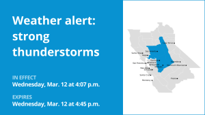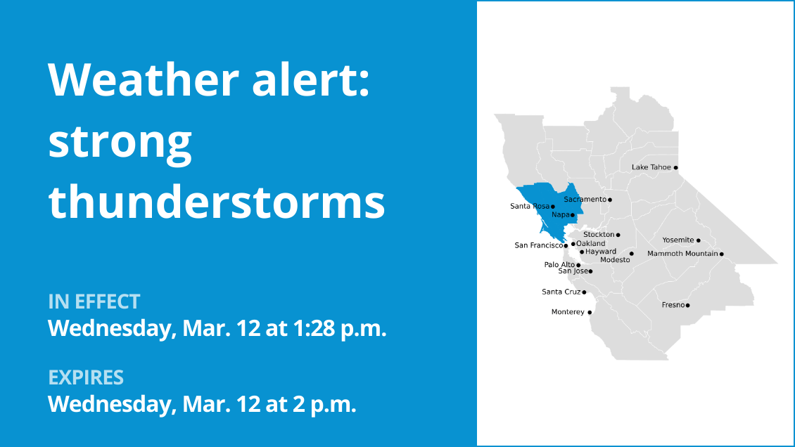
Marin Coastal Range, Sonoma Coastal Range, North Bay Interior Mountains, Coastal North Bay including Point Reyes National Seashore and North Bay Interior Valleys are the focus of a weather alert for strong thunderstorms issued at 1:28 p.m. on Wednesday by the National Weather Service. The alert is in effect until 2 p.m.
“At 1:28 p.m., Doppler radar tracked a line of strong thunderstorms extending from 9 miles southwest of Healdsburg to 26 miles southwest of Point Reyes Station, or extending from 14 miles west of Santa Rosa to 33 miles southwest of San Rafael, moving northeast at 50 mph,” according to the NWS San Francisco CA. “Gusty winds could knock down tree limbs and blow around unsecured objects.”
Locations impacted by the alert include Santa Rosa, Petaluma, Novato, Rohnert Park, Windsor, Healdsburg, Sonoma, Sebastopol, Cotati, St. Helena, Calistoga, South Santa Rosa Cdp, Roseland, Larkfield-Wikiup, Tomales, Boyes Hot Springs, Dillon Beach, Point Reyes Station, Black Point-Green Point and Lucas Valley-Marinwood.
According to the NWS, “Monitor the weather situation closely and be alert for threatening weather conditions. Torrential rainfall is also occurring with these storms and may lead to flash flooding. Do not drive your vehicle through flooded roadways.”
Preparing for approaching lightning: Expert safety advice
Lightning strikes the United States approximately 25 million times each year, with the bulk of these electrical discharges occurring during the summer months. Tragically, lightning claims the lives of about 20 individuals annually, as reported by the NWS. The risk of lightning-related incidents escalates as thunderstorms draw near, reaching its peak when the storm directly looms overhead. However, it gradually recedes as the tempest moves away.
To ensure your safety during a thunderstorm, consider the following recommendations:
Lightning safety plan:
When venturing outdoors, it’s vital to establish a clear plan for seeking shelter in case of lightning.
Stay vigilant by monitoring the sky for ominous signs and listening for the telltale sound of thunder. If thunder is audible, it’s a clear indication of nearby lightning.
Seek a safe place to shelter, preferably indoors.
Indoors safety measures:
Once you’re indoors, avoid using corded phones, electrical devices, plumbing fixtures, and stay away from windows and doors.
These precautions help reduce the risk of electrical surges, as lightning can follow conductive pathways.
Wait for the all-clear:
After the last lightning strike or thunderclap, wait at least 30 minutes before resuming outdoor activities.
Lightning can strike even when a storm has seemingly passed, so exercise caution.
When indoor shelter isn’t available:
If you find yourself outdoors with no access to indoor shelter during a thunderstorm, take these steps to maximize your safety:
Avoid open fields, hilltops, or ridge crests, which expose you to greater lightning risk.
Steer clear of tall, isolated trees and other prominent objects. In wooded areas, stay close to lower stands of trees.
If you’re in a group, ensure that individuals are spaced out to prevent lightning current from transferring between people.
Camping in an open setting during a thunderstorm is strongly discouraged. If no alternative exists, set up camp in a valley, ravine, or other low-lying areas. Remember that a tent offers no protection against lightning.
Do not approach water bodies, wet objects, or metal items. While water and metal don’t attract lightning, they conduct electricity effectively and can pose significant risks.
In summary, when facing the threat of lightning, preparedness and vigilance are your best allies. By following these guidelines, you can significantly reduce the likelihood of lightning-related incidents and prioritize your safety.
Rainy roadways ahead: Essential safety tips for heavy rain
When heavy rain strikes, safety is paramount. Equip yourself with these guidelines from the NWS to navigate wet roads and avoid hazards:
Beware of rapid water flow:
During heavy rain, avoid parking or walking near culverts or drainage ditches, where swift-moving water can pose a serious risk.
Maintain safe driving distances:
The two-second rule for following distance is your ally in heavy rain. Extend it to four seconds to ensure safe spacing in adverse conditions.
Slow down and drive with care:
On wet roads, slowing down is paramount. Gradually ease off the accelerator and avoid abrupt braking to prevent skidding.
Choose your lane wisely:
Stick to the middle lanes on multi-lane roads to minimize the risk of hydroplaning, as water tends to accumulate in outer lanes.
Prioritize visibility
Turn on your headlights and be careful of other vehicles to the rear and in blind spot areas as they are especially difficult to see through rain-spattered windows.
Watch out for slippery roads:
The initial half-hour of rain is when roads are slickest due to a mixture of rain, grime, and oil. Exercise heightened caution during this period.
Keep a safe distance from large vehicles:
Large trucks and buses can reduce your visibility with tire spray. Avoid tailgating and pass them swiftly and safely.
Mind your windshield wipers:
Overloaded wiper blades can hinder visibility. If rain severely impairs your vision, pull over and wait for conditions to improve. Seek refuge at rest areas or sheltered spots.
If the roadside is your only option, pull off as far as possible, preferably past the end of a guard rail, and wait until the storm passes. Keep your headlights on and turn on emergency flashers to alert other drivers of your position.
In the face of heavy rain, these precautions can make a significant difference in ensuring your safety on the road. Remember to stay informed about weather conditions and heed guidance from local authorities for a secure journey.