Jamaica is bracing for a near-direct strike from Category 4 Hurricane Beryl on Wednesday, after the record-breaking storm left multiple people dead on islands in the eastern Caribbean.
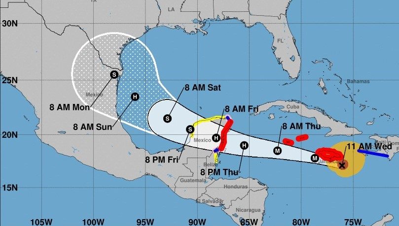
The Cayman Islands and Mexico’s Yucatan Peninsula are in Beryl’s path later in the week, and the southern Gulf coast of Texas, including Corpus Christi, was in Beryl’s forecast cone of uncertainty for late in the weekend.
Hurricane Beryl could bring life-threatening storm surge from six to nine feet, flash flooding and mudslides to Jamaica and Haiti, and officials are warning residents to take shelter or evacuate the most prone areas.
As of 2 p.m. Wednesday, Beryl was 45 miles south of Kingston, Jamaica, paralleling the southern coast of the island, with maximum sustained winds of 140 mph. The hurricane is traveling west-northwest at 18 mph.
Hurricane-force winds extend outward up to 45 miles from the center and tropical-storm-force winds extend outward up to 185 miles.
After passing Jamaica, Hurricane Beryl will track near or over the Cayman Islands on Wednesday night or early Thursday before approaching the Yucatan Peninsula just south of Tulum and Cancun as a weaker hurricane on Thursday night.
Mexico has issued a hurricane warning for the coast of the Yucatan Peninsula from Puerto Costa Maya near the Belize border north to Cancun.
A tropical storm watch is in effect for the coast of Belize from south of Chetumal to Belize City.
Forecasters said Beryl will weaken over the Yucatan but could regain hurricane strength as it moves back over water in the Bay of Campeche and then the Gulf of Mexico. The southern half of Texas’ Gulf Coast was in the forecast cone of uncertainty as of Wednesday morning.
“We are most concerned about Jamaica, where we are expecting the core of a major hurricane to pass near or over the island,” National Hurricane Center Director Michael Brennan said in an online briefing Tuesday. “You want to be in a safe place where you can ride out the storm … Be prepared to stay in that location through Wednesday.”
Even if the eye of the storm doesn’t make landfall on Jamaica, the island will take a blow from the upper right quadrant, the strongest and most devastating part of a hurricane.
“I am encouraging all Jamaicans to take the hurricane as a serious threat,” Prime Minister Andrew Holness said in a public address late Monday. “It is, however, not a time to panic.”
The Cayman Islands could see between 2 and 4 feet of storm surge. Though Haiti and the Dominican Republic are not in the direct path of Beryl, the hurricane is close enough to bring a potential storm surge of 1 to 3 feet along the southern coasts, the hurricane center said.
Record-breaking storm
Late Monday, Beryl became the earliest storm to develop into a Category 5 hurricane in the Atlantic and peaked at winds of 165 mph Tuesday before weakening to a still-destructive Category 4. It was the first Category 4 storm to occur in June and the earliest Category 4 on record in the Atlantic Basin.
The storm strengthened from a tropical depression to a major hurricane in just 42 hours, which only six other Atlantic hurricanes have done, and never before September, according to hurricane expert Sam Lillo.
Fisherman Hamilton Cosmos looks at vessels damaged by Hurricane Beryl at the Bridgetown Fisheries in Barbados, Monday, July 1, 2024. (AP Photo/Ricardo Mazalan)
Beryl made landfall Monday in the Grenadine Islands north of Grenada as a powerful Category 4 storm with sustained winds of 155 mph, just shy of the minimum Category 5 threshold of 157 mph.
At least six people have died.
Three people were reported killed in Grenada and Carriacou and another in St. Vincent and the Grenadines, officials said. Two other deaths were reported in northern Venezuela, where five people were missing, officials said. Some 25,000 people in that area also were affected by heavy rainfall from Beryl.
Family members survey their home destroyed in the passing of Hurricane Beryl, in Ottley Hall, St. Vincent and the Grenadines, Tuesday, July 2, 2024. (AP Photo/Lucanus Ollivierre)
One fatality in Grenada occurred after a tree fell on a house, Kerryne James, minister of climate resilience, environment and renewable energy, told The Associated Press.
“The situation is grim,” Grenadian Prime Minister Dickon Mitchell told a news conference Tuesday. “There is no power, and there is almost complete destruction of homes and buildings on the island. The roads are not passable, and in many instances they are cut off because of the large quantity of debris strewn all over the streets.”
Mitchell added: “The possibility that there may be more fatalities remains a grim reality as movement is still highly restricted.”
Grand Cayman, Little Cayman and Cayman Brac were under a hurricane warning Wednesday.
Forecasters said Tuesday night that Beryl is expected to weaken in the next few days but will remain a hurricane in the northwestern Caribbean.
Next storm being tracked
The National Hurricane Center is also keeping an eye on a tropical wave, located a couple hundred miles east-southeast of the Windward Islands in the Atlantic on Monday, which could become a tropical depression by midweek as it moves across the western Atlantic and eastern Caribbean.
As of 8 a.m. Wednedsay, forecasters gave it a 10% chance of developing in the next two days and a 20% chance over the next week. It is expected to move west at 15 mph to 20 mph, forecasters said.
If it develops, it would be named Debby and follow a very similar path as Hurricane Beryl into the Caribbean Sea.
Hurricane Beryl is nearing Jamaica as a second, weaker system follows it its path. (Courtesy NHC)
The western Gulf of Mexico generated the 2024 season’s first tropical storm last week. Dubbed Alberto, the system made landfall in Mexico 250 miles south of the U.S. border, but sent storm surge and flood to spots 500 miles away in Louisiana.
Information from The Associated Press was used to supplement this news article.


