You won’t need to clean out the gutters. Or put new wiper blades on the car. Or even dig your umbrella from the back of the closet. But rain is in the forecast. That’s right. Not a typo.
A rare August cold front is expected to bring gusty winds, cooler weather and a chance of rain Friday into Saturday morning across Northern California and parts of the Bay Area. The Sierra Nevada may even see a light dusting of snow.
“It’s rare for August. It’s not like we’ve never seen it before, but it only happens about every two years or so,” said Jan Null, a meteorologist with Golden Gate Weather Services in Half Moon Bay. “We’ll get some drizzle on the coast, and light rain in the North Bay. As you go south from Sonoma County, the odds drop. But after July’s heat, any change from hot and sunny is a welcome change.”
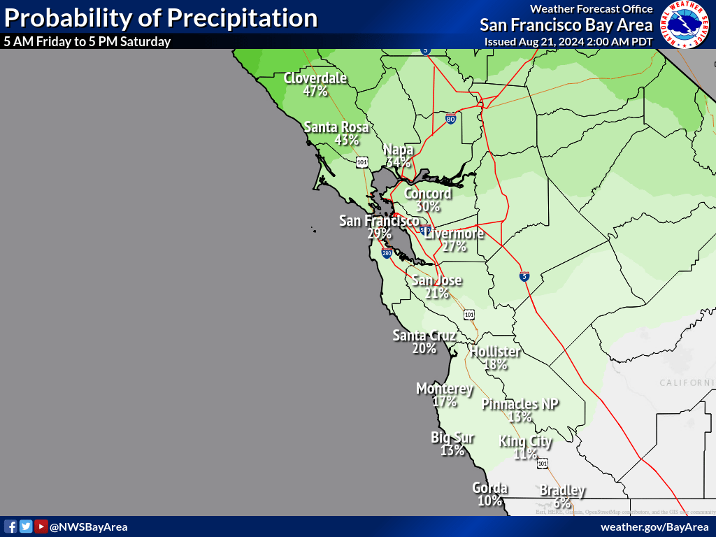
The storm system is expected to bring significant rain to Washington and Oregon this week, with amounts lessening farther south. Combined rainfall totals forecast for Friday and Saturday, the National Weather Service said Wednesday, are .53 inches in Redding; .42 in Chico; .30 in South Lake Tahoe; .29 in Sacramento; .26 in Ukiah; .14 in Santa Rosa; .09 in San Francisco; and .07 in Fremont.
Chances of rain are only 20% in San Jose, which may well miss any measurable precipitation.
Friday will be the coolest day of the week in the Bay Area, with temperatures expected to range from the upper 50s near the coast to mid 70s inland. That’s 10 to 15 degrees below average for this time of year.
It may not look like much, but the band of clouds over British Columbia is the disturbance that will result in a cooling trend starting on Thursday and giving us a chance of light rain (and by that we mean less than 0.1″ total) on Friday and Saturday. #CAwx pic.twitter.com/IjSRuHZlqS
— NWS Bay Area (@NWSBayArea) August 21, 2024
How rare is rain in August? Northern California receives most of its annual rainfall during the winter, with roughly 75% of the yearly total falling in December, January, February and March.
August is the second-driest month of the year in the Bay Area, behind July. The historical average over the past 30 years in San Francisco during the entire month of August is only .06 of an inch — about the thickness of a dime. In Oakland and San Jose, it’s even less, .04 inches and .05 respectively.
If the Bay Area receives a mild amount of rain Friday and Saturday, it will likely be the wettest day in three months, since .07 inches fell in downtown San Francisco on May 25.
The storm system also is expected to bring a rare dusting of snow to the Sierra, with less than 1 inch forecast above 8,000 feet, according to the National Weather Service.
“We’re expecting a very low accumulation,” said Bakari Anderson, a meteorologist with the National Weather Service in Sacramento. “Probably about half an inch at the highest elevations. It’s not something we typically see this time of year. There may be some slippery roads, but nothing we’re overly concerned about.”
The heavier amounts of rain forecast in farther Northern California could cause problems, however.
On Wednesday, the National Weather Service issued a flash flood watch from 11a.m. Friday to 11 a.m. Saturday for the burn scar of the Park Fire, warning of rockslides and mudslides. The Park Fire, which began July 24, has burned 429,460 acres — an area 14 times the city of San Francisco — in rural parts of Butte and Tehama counties north of Chico, making it the fourth largest wildfire in California history.
On Wednesday, it was 57% contained with most of the spread limited. The fire began, authorities said, when Chico resident Ronnie Dean Stout II, pushed a car he had been driving down an embankment near Chico after it stalled and began burning nearby grass. Stout was arrested and charged with arson. The fire has burned 637 structures, with no fatalities.
From a water standpoint, California is in good shape this summer.
After three years of drought in 2020, 2021 and 2022, the state received heavy storms and the biggest Sierra snowpack in 40 years in 2023, and above-average rain and snow again this past winter, which filled reservoirs across the state.
From Oct. 1 through Wednesday, San Francisco has received 25.72 inches of rain, or 113% of its historic average. San Jose has received 17.06 inches, or 127% of normal, and Oakland has received 16.32 inches or 88% of normal.
Southern California has exceeded rainfall averages even more this year. Los Angeles is at 157% of its normal rainfall since Oct. 1 and San Diego has seen 128% of normal.
Any rain that falls across Northern California and the Bay Area on Friday and Saturday will temporarily reduce fire danger for a few days, Null noted. And it will wash soot from the Park Fire out of the air.
But starting Monday, the system will move out, and more typical summer weather will return with the mercury creeping back into the 80s and 90s.