A tsunami warning has been lifted after a magnitude 7.0 earthquake struck off the coast of northern California on Thursday morning, rattling cities as far south as Oakland, shutting down BART’s Transbay Tube and causing major BART delays system wide.
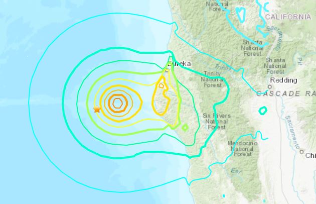
The epicenter of the quake, which struck at 10:44 a.m., was under the Pacific Ocean, about 65 miles off the coast of Eureka in Humboldt County, originating about 0.6 miles below ground. The strongest shaking occurred in the small town of Petrolia.
There were no immediate reports of injuries or damage.
No tsunami danger exists for the U.S. west coast, British Columbia or Alaska.according to the U.S. Tsunami Warning Center. The tsunami had been expected to reach the San Francisco Bay shortly after noon, with the possibility of widespread, dangerous coastal flooding. People were advised to evacuate to higher ground or a tall building immediately.
Thursday’s quake occurred along a restless region where three tectonic plates converge, called the Mendocino Triple Junction, where the Pacific, Gorda, and North American tectonic plates meet. It is considered part of the Cascadia subduction zone which extends further north along the coast; this area is known for frequent earthquake activity due to the complex plate interactions there.
It was preceded on Wednesday morning by two earthquakes measuring 4.4 and 4.2 magnitude, also west of Eureka.
The earthquake is unrelated to the Bay Area’s three major faults. The San Andreas Fault runs roughly 750 miles through California between Cape Mendocino to San Diego, including the San Francisco Peninsula. The Hayward Fault runs roughly 74 miles along the western base of the densely populated East Bay Hills.The Calaveras Fault runs roughly 76 miles from Hollister to Danville.
The earthquake had one local impact immediately: It shut down BART’s Transbay Tube and caused major delays system wide.
BART spokesperson Chris Filippi said that because of the tsunami warning, all trains will be held out of the Tube until further notice. He added that the agency routed trains that travel the yellow (Antioch to San Francisco), blue (Daly City to Dublin/Pleasanton), green (Daly City to Berryessa/North San Jose) and red (Richmond to Millbrae) lines to avoid the Tube.
“We are advising trans-bay riders to find alternate means of transportation,” Filippi said.The agency also cleared trains out of their underground stations that are on the western side of the San Francisco Bay, Filippi said.
For northern Californians, the most likely source of a dangerous quake is the Hayward-Rodgers Creek Fault, with a 31 percent chance in the next 30 years. This fault runs through the heart of East Bay cities. The Hayward section of the fault runs from near Mount Misery, east of San Jose, north to San Pablo Bay. The Rodgers Creek portion picks up from there and runs north to Santa Rosa.
The last major earthquake in the Bay Area was the 1989 Loma Prieta earthquake — a magnitude 6.9 quake that struck on Oct. 17, 1989, in the Santa Cruz Mountains. It killed 62 people and caused $6 billion in damages. The largest earthquake since Loma Prieta shook Napa in August 2014 with a magnitude of 6.0. No one was killed in the quake but hundreds of buildings were damaged and dozens were red-tagged. Before that, a magnitude 5.4 temblor hit near Alum Rock in San Jose in 2007.
In 2014, a panel of experts estimated that there is a 72 percent chance that in the next 30 years the San Francisco Bay Area will experience an earthquake at least as powerful as the magnitude 6.7 Northridge earthquake that rocked Southern California in 1994. There is a far greater chance — 99 percent — that a smaller but still substantial magnitude 6.0 earthquake will strike during that time.
Related Articles
3.6-magnitude earthquake strikes 32 miles off Southern California Coast
Great California Shakeout: Earthquake drill comes on Loma Prieta quake’s 35th anniversary
Quake mystery: 2024 brings most seismic activity to Southern California in decades. Why now?
3 Bay Area counties are among the most at risk in U.S. for natural disasters. One is trying to improve its preparedness.
Elias: Ricardo Lara, Gavin Newsom caving in to California’s insurers they regulate
The scale of earthquake measurement is logarithmic: a recording of 7, for example, signifies a disturbance with ground motion 10 times as large as a recording of 6. An earthquake of magnitude 2 is the smallest size normally felt by humans. Earthquakes measuring 5 or higher are potentially damaging.
The San Francisco earthquake of 1906 has been estimated at a magnitude 8.3. The earthquake that leveled the capital of Haiti measured 7.
As with any large earthquake, there is a possibility of damaging aftershocks. If an aftershock occurs, the USGS recommends that people who are indoors stay there, taking shelter under a piece of furniture, in a hallway or against an inside wall, away from windows, fireplaces and heavy objects.
If you are outdoors, get into the open away from buildings, power lines and other things that could fall. If driving, stop carefully and move out of traffic. Avoid bridges, trees and other falling objects. Stay in your car until the shaking stops.
Check back for more on this breaking news story as it develops.
