After an unusually dry January where most of Northern California went without rain for 27 days in a row, the storms have come fast and furious, dramatically improving the state’s water supply outlook.
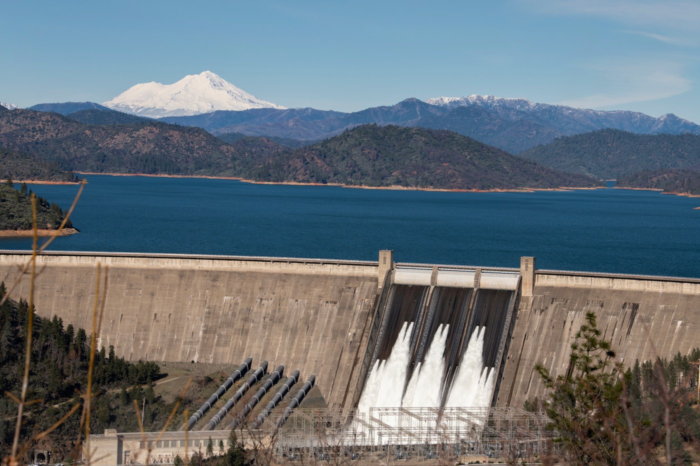
So much rain fell in the first week of February that California’s largest reservoir, Shasta Lake, near Redding, rose 22 feet. Shasta Lake reservoir is 34 miles long. The watershed at it second-largest, Lake Oroville, in Butte County, has received 24 inches of rain in the past two weeks — five times the historical average.
And now a new atmospheric river storm is forecast to soak the Bay Area and the rest of the state Thursday and Friday.
“We’ve had two good years in a row prior to this, and we are heading into a third year,” said Jeff Mount, a professor emeritus at UC Davis and senior fellow at the Public Policy Institute of California’s water center. “I can confidently say we are in really good shape. It’s unusual to get three wet years in a row.”
The wet winter conditions in Northern California come as welcome relief after the state suffered serious droughts in 11 of the past 17 years: 2007-09, 2012-16, and 2020-22.
The latest storm charging in from the Pacific is a category 1 or 2 atmospheric river on a scale of 1 to 5, with 5 being the strongest, according to scientists at the Scripps Institution of Oceanography at UC San Diego.
Forecasters said it is expected to deliver about 2 inches of rain to most Bay Area cities Thursday and Friday, 3 to 5 inches in the Santa Cruz Mountains, and 4 to 6 inches in Big Sur, with the heaviest rain from midnight to 6 a.m. Thursday morning.
“There could be local impacts,” said Jan Null, a meteorologist with Golden Gate Weather Services in Half Moon Bay. “A slower morning commute, clogged gutters. It will be breezy. But no major flood risk. The models have backed off on this one.”
Concerns are higher for the Los Angeles area, where there are fears of mudslides and debris flows in areas that burned last month in the Palisades and Eaton fires.
Ever since October, Northern California has seen consistently more rain than Southern California. On Wednesday, San Francisco had received 105% of its normal rainfall, while Los Angeles had received only 31% of its historical average. The last two weeks in Northern California north of Interstate 80 have been very wet.
The rain has been so plentiful that operators of the largest reservoirs have been increasing water releases in recent days to make space for the latest storm.
At Shasta Lake, federal dam operators have let out 60,000 cubic feet per second since Saturday through the outlet valves at the massive Shasta Dam. That’s 450,000 gallons a second, the equivalent of 40 Olympic swimming pools every minute.
Raging torrents of water have cascaded into the Sacramento River, sending the 34-mile-long reservoir, a key linchpin of the state’s water supply, from 90% full on Friday to 84% full Wednesday.
“It’s always troubling for people to see water let out,” Mount said. “But you have to keep some space to catch floods, and then hope the melting snow in the spring fills the reservoir back to the top.”
Mount said he fully expects both Shasta and Oroville to be full this spring as runoff continues from the storms, and later, from the melting Sierra snowpack. That means there should be no water restrictions again this summer for cities in most of Northern California, he said.
Similarly, at Oroville Dam, south of Chico, the state’s second-largest reservoir at Lake Oroville rose 23 feet from Feb. 1 to Feb. 7 amid a series of big storms. State dam operators are releasing 30,000 cubic feet per second, lowering it to 83% full on Wednesday.
It’s a delicate balancing act, experts say. If reservoirs fill to the top too quickly in big storms, large amounts of water are released down their spillways, causing flooding to homes and communities downstream. In extreme cases, water can overtop dams, causing a risk of failure.
Operators at most large dams in California rely on a manual called a “rule curve,” which is set by the U.S. Army Corps of Engineers. Evaluating decades of rainfall patterns, it recommends the highest level that each reservoir should be kept at every day, an amount that gradually increases later in the spring as winter storms dissipate.
“You are playing the odds,” Mount said. “What you are trying to do is balance the risk of not ending up with enough water in the spring against the risk of having too much in the winter, where you’ll get flooding.”
On Wednesday, nearly every major reservoir in the state, including in Southern California, was above its historical average, the product of three wet winters, and the state and federal systems that move water from the wetter north to the drier south. In California, 75% of the precipitation falls in the north, but 75% of the people live in the south.
Thursday’s storm was also expected to boost the Sierra Nevada snowpack, the source of about one-third of the state’s water supply each year. The National Weather Service issued a winter storm warning for the Sierra Nevada through 10 p.m. Friday. Forecasters said the Lake Tahoe area would receive 2 to 4 feet of snow with winds at the highest elevations up to 100 mph, with road closures likely on Thursday and Friday.
The Northern Sierra snowpack was 110% of normal Wednesday, but the Southern Sierra was at just 55%.
After Friday’s storm, the Bay Area should expect dry conditions for at least a week, Null said.
“It’s going to move through our area pretty rapidly,” he added.